The first mentions of the Volga River date back to ancient times, when it was called “Ra”. In later times, already in Arabic sources, the river was called Atel (Etel, Itil), which translated means “ great river"or "river of rivers." This is exactly what the Byzantine Theophanes and subsequent chroniclers called it in the chronicles.
The current name "Volga" has several versions of its origin. The most likely version seems to be that the name has Baltic roots. According to the Latvian valka, which means “overgrown river”, the Volga got its name. This is exactly what the river looks like in its upper reaches, where the Balts lived in ancient times. According to another version, the name of the river comes from the word valkea (Finno-Ugric), which means “white” or from the ancient Slavic “vologa” (moisture).
Since ancient times, the Volga has not lost any of its greatness. Today it is the largest river in Russia and ranks 16th in the world among the longest rivers. Before the construction of the cascade of reservoirs, the length of the river was 3690 km; today this figure has been reduced to 3530 km. At the same time, shipping navigation is carried out over 3500 km. In navigation, the Canal plays an important role. Moscow, which acts as a link between the capital and the great Russian river.
The Volga is connected to the following seas:
The waters of the Volga originate in the Valdai Upland region - in the spring of the village of Volgo-Verkhovye, which is located in the Tver region. The height of the source above sea level is 228 meters. Then the river carries its waters throughout Central Russia into the Caspian Sea. The height of the river's fall is small, because the mouth of the river is only 28 meters below sea level. Thus, along its entire length the river descends 256 meters, and its slope is 0.07%. average speed The river flow is relatively low - from 2 to 6 km/h (less than 1 m/s).
The Volga is fed mainly by meltwater, which accounts for 60% of the annual flow. 30% of the flow comes from groundwater (they support the river in winter) and only 10% comes from rain (mainly in summer period). Along its entire length, 200 tributaries flow into the Volga. But already at the latitude of Saratov, the river’s water basin narrows, after which from the city of Kamyshin the Volga flows to the Caspian Sea without support from other tributaries.
The Volga from April to June is characterized by high spring floods, which last on average 72 days. The maximum level of water rise in the river is observed in the first half of May, when it spills over the floodplain area for 10 kilometers or more. And in the lower reaches, in the Volga-Akhtuba floodplain, the width of the spill in some places reaches 30 km.
Summer is characterized by a stable low-water period, which lasts from mid-June to early October. Rains in October bring with them an autumn flood, after which a period of low-water winter low water begins, when the Volga is fed only by groundwater.
It should also be noted that after the construction of a whole cascade of reservoirs and regulation of flow, fluctuations in water levels became much less significant.
The Volga freezes in its upper and middle reaches usually at the end of November. On the lower reaches, ice appears in early December.
Ice drift on the Volga in the upper reaches, as well as in the area from Astrakhan to Kamyshin, occurs in the first half of April. In the area near Astrakhan, the river usually opens in mid-March.
Near Astrakhan, the river remains ice-free for almost 260 days a year, while in other areas this time is about 200 days. During open water the river is actively used for ship navigation.
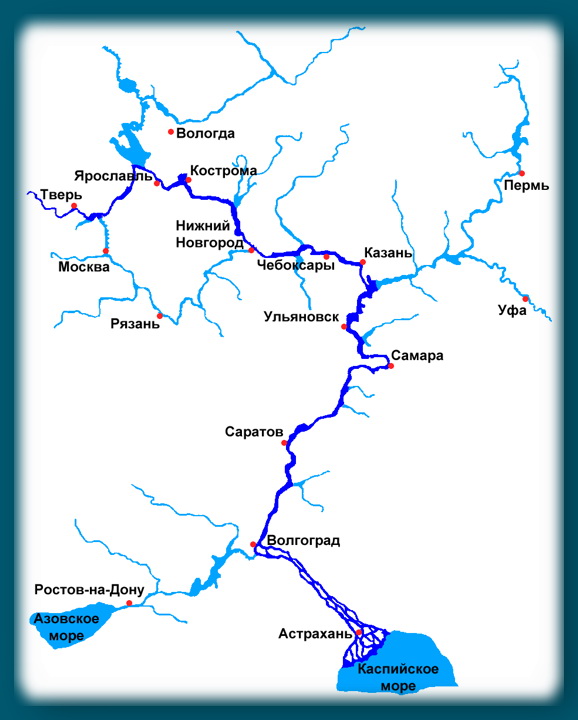
The main part of the river's catchment area is in the forest zone, located from the very sources to Nizhny Novgorod. The middle part of the river flows through the forest-steppe zone, and the lower part flows through semi-deserts.
Volga map
According to the classification accepted today, the Volga in its course is divided into three parts:
As for the Lower Volga, some adjustments should be made. After the construction of the Zhigulevskaya hydroelectric power station just above Samara and the structures Kuibyshev Reservoir, the current border between the middle and lower sections of the river runs exactly at the level of the dam.
In its upper course, the river made its way through the system of Upper Volga lakes. Between Rybinsk and Tver, 3 reservoirs are of interest to fishermen: Rybinsk (the famous “rybinka”), Ivankovskoe (the so-called “Moscow Sea”) and the Uglich Reservoir. Even further down its course, past Yaroslavl and to Kostroma, the river bed runs along a narrow valley with high banks. Then, slightly higher than Nizhny Novgorod, there is the Gorky Hydroelectric Power Station dam, which forms the Gorky Reservoir of the same name. The most significant contribution to the Upper Volga is made by such tributaries as: Unzha, Selizharovka, Mologa and Tvertsa.
Beyond Nizhny Novgorod the Middle Volga begins. Here the width of the river increases by more than 2 times - the Volga becomes full-flowing, reaching a width of 600 m to 2+ km. After the construction of the Cheboksary hydroelectric power station of the same name, an extended reservoir was formed near the city of Cheboksary. The area of the reservoir is 2190 square km. The largest tributaries of the Middle Volga are the rivers: Oka, Sviyaga, Vetluga and Sura.
The Lower Volga begins immediately after the confluence of the Kama River. Here the river can truly be called powerful in all respects. The Lower Volga carries its deep streams along the Volga Upland. Near the city of Tolyatti on the Volga, the most large reservoir– Kuibyshevskoe, where in 2011 there was a disaster with the notorious motor ship Bulgaria. The reservoir of the Volzhskaya Hydroelectric Power Station named after Lenin is propped up. Even further downstream, near the city of Balakovo, the Saratov hydroelectric power station was built. The tributaries of the Lower Volga are no longer so rich in water, these are the rivers: Samara, Eruslan, Sok, Bolshoy Irgiz.
Below the city of Volzhsky, a left branch called Akhtuba separates from the great Russian river. After the construction of the Volzhskaya hydroelectric power station, the beginning of Akhtuba became a 6 km canal extending from the main Volga. Today, the length of Akhtuba is 537 km, the river carries its waters to the northeast parallel to the mother channel, then approaching it, then moving away again. Together with the Volga, Akhtuba forms the famous Volga-Akhtuba floodplain - a real fishing eldorado. The floodplain area is pierced by numerous channels, full of flooded lakes and unusually rich in all kinds of fish. The width of the Volga-Akhtuba floodplain ranges from 10 to 30 km on average.
Through the territory of the Astrakhan region, the Volga travels a distance of 550 km, carrying its waters along the Caspian lowland. At the 3038th kilometer of its path, the Volga River splits into 3 branches: Krivaya Bolda, Gorodskoy and Trusovsky. And on the section from 3039 to 3053 km along the Gorodskaya and Trusovsky branches, the city of Astrakhan is located.
Below Astrakhan, the river turns southwest and splits into numerous branches that form a delta.
The Volga Delta first begins to form at the place where one of the branches called Buzan separates from the main channel. This place is located above Astrakhan. In general, the Volga delta has over 510 branches, small channels and eriks. The delta is located on total area 19 thousand square kilometers. The width between the western and eastern branches of the delta reaches 170 km. In the generally accepted classification, the Volga delta consists of three parts: upper, middle and lower. The upper and middle delta zones consist of small islands, separated by channels (eriks) ranging from 7 to 18 meters wide. The lower part of the Volga delta consists of very branched channel channels, which turn into the so-called. Caspian peals, famous for their lotus fields.
Due to the decrease in the level of the Caspian Sea over the past 130 years, the area of the Volga delta is also growing. During this time it increased more than 9 times.
Today the Volga delta is the largest in Europe, but is famous primarily for its rich fish stocks.
Note that plant and animal world The delta is under protection - the Astrakhan Nature Reserve is located here. Therefore, recreational fishing in these places is regulated and is not allowed everywhere.

Since the 30s of the last century, electricity began to be produced on the river using hydroelectric power stations. Since then, 9 hydroelectric power stations with their own reservoirs have been built on the Volga. At the moment, the river basin is home to approximately 45% of industry and half of all Agriculture Russia. The Volga basin produces over 20% of all fish for the Russian food industry.
The logging industry is developed in the Upper Volga basin, and grain crops are grown in the Middle and Lower Volga regions. Horticulture and vegetable farming are also developed along the middle and lower reaches of the river.
The Volga-Ural region is rich in deposits natural gas and oil. Potassium salt deposits are located near the city of Solikamsk. The famous Lake Baskunchak on the Lower Volga is famous not only for its healing mud, but also for its deposits of table salt.
Upstream, ships transport petroleum products, coal, gravel materials, cement, metal, salt and food products. Timber, industrial raw materials, lumber and finished products are supplied downstream.

In the mid-90s of the last century, due to the economic decline in the country, water tourism on the Volga lost its popularity. The situation was normalized only at the beginning of this century. But it prevents you from developing tourism business outdated material and technical base. Motor ships that were built back in the Soviet times(60-90 years of the last century). Water tourist routes along the Volga quite a lot. From Moscow alone, ships sail on more than 20 different routes.
The Volga is the longest European river, as well as one of the largest on planet Earth, which is located in the European part of Russia and Kazakhstan.
At the moment, the length of the Volga is approximately 3530 km, although before the construction of reservoirs on the river, it was somewhat longer - 3690 km.
The Volga got its name from the times of Rus' and comes from the word “moisture”.
The source of the Volga River is located on the Valdai Hills, namely in the small village of Volgoverkhovye, in the Tver region. The river then passes through several large lakes. A special monument to the river was erected at the source site.
Like many other Russian rivers, the Volga is predominantly fed by snow - approximately 60%, a small part is fed by rain - only 10%, and groundwater actually feed the Volga by 30%. Annual fluctuations in water levels vary in different regions. For example, in the Tver region it can reach 11 meters, in Astrakhan - only 3 meters.

Volga river photo
The water in the river is advantageously warm, summer time, for example, it does not fall below 20-25 degrees Celsius. The river freezes at the end of November - in the upper reaches, and in the lower reaches already in December. The river is frozen 100 to 160 days a year. Frequent on the Volga River big waves- about 1.5 - 2 meters. Because of this, breakwaters were installed in many ports.
The Volga River, as well as its largest tributary, the Kama, are a source of huge quantities of fish. The river contains large populations the following types fish: crucian carp, silver bream, pike perch, perch, ide, pike, catfish, burbot, ruff, sturgeon, bream and sterlet. Trout have recently been released into the rivers. In total, there are about 70 species of fish in the Volga.

Birds on the Volga River photo
Many species of birds live in the deltas of the Volga: ducks, swans, herons, etc. Although the Volga is heavily polluted by industrial enterprises, it still retains quite rich aquatic vegetation (lotus, water lily, reed, water chestnut, etc.), especially in the bays.
The most important cities for the country are located on the Volga, including many cities with a population of millions. At the very bottom of the Volga lies the most important economic and industrial center of the Lower Volga region - the city of Astrakhan, with a population of more than half a million. Astrakhan is considered to be a port city.

Volga river. Astrakhan city photo
One of the most beautiful and most famous cities is the large city of Volgograd, formerly called Stalingrad. The city has a heroic title, which it received during the Great Patriotic War(). The city's population is slightly more than 1 million people. Even under the USSR it was one of the most powerful economically developed cities in the country. Now the city has a thriving mechanical engineering, construction industry, metallurgy, and energy industries.

Volga river. Volgograd city photo
One of the largest cities in terms of population on the Volga is the city of Kazan. Its population is more than 1 million, 200 thousand people. Kazan is one of the most powerful industrial centers Russian Federation. The basis of the city's industry is mechanical engineering, petrochemical industry, aviation industry. No less big city on the Volga there is Nizhny Novgorod with a population of 1 million, 250 thousand people. Although, unlike the population of Kazan, the population here is not growing, but falling.

Volga river. Kazan city photo
There is a wide production of cars, ships various classes and weapons production. Heavy industry is well developed in the city. Novgorod is also considered one of the main information centers of a large country. The next city to note is with a population of almost 1 million and 200 thousand people. Samara is an important center of mechanical engineering and heavy industry, and in particular the aviation industry.

Volga river. Nizhny Novgorod photo
The last city that needs to be mentioned is the city of Tver with a population of just over 400 thousand people. Tver is the most developed in the engineering sector and heavy industry. Slightly less developed food industry, as well as chemical.
About 200 tributaries flow into the Volga and most of them are on the left side. The left tributaries are also much richer in water than the right tributaries. The largest tributary of the Volga is the Kama River - a left tributary. Its length reaches 2000 km, which is more than half the length of the Volga itself. The influx begins on the Verkhnekamsk Upland.
The Kama is distinguished by a huge number of small tributaries - their total number reaches almost 74 thousand, and the lion's share of them (approximately 95%) are rivers up to 10 km long. Like the Volga, the Kama is predominantly snow-fed. Water level fluctuations most often range from 6 to 7 meters.
Many hydraulic engineering studies also suggest that the Kama is much older than the Volga and that the Volga is a tributary of the Kama, and not vice versa. Just a few thousand years ago this was exactly the case. But the last one glacial period and the construction of reservoirs on the Kama, seriously reduced its length.
Tributaries of the Volga:
The Volga is rightfully considered one of the most picturesque rivers in Russia, and therefore tourism is thriving on it. Volga gives the opportunity to maximize short term visit a large number of ancient cities of the state.
Cruises on the Volga are the most common type of vacation on the Volga, as well as one of the most versatile, comfortable and relatively inexpensive. Such a cruise can last from several days to a whole month, which includes visits to the most beautiful cities and places of the country located along the Volga.

Tourism on the Volga River photo
The most favorable period for traveling along the Volga is the beginning of May to the end of September, when the weather is warmest and most pleasant. The most convenient transport for traveling is a tourist ship, which has all the amenities for passengers, including: swimming pools, comfortable high-class cabins, cinemas, a library and so on. When the ship enters the city, tourists can easily book a tour of a particular city.
Payment for excursions may also be included in the property of the tourist tour itself, along with payment for the ship.
Volga river the largest and deepest river in Europe. Ancient name Ra (lat. Rha) the less old name of Vloga is Itil, the river received in the Middle Ages. This is the largest river that does not flow into the sea. 2/3 of Russia's population lives in the Volga basin. Its source is located on the Valdai Hills at an altitude of 256 m above sea level. And at the mouth, on the northern coast of the Caspian Sea, in its delta there are the largest lotus fields in the world, occupying hundreds of hectares.
Here is what Alexander Dumas wrote about the Volga: “Every country has its own national river. Russia has the Volga - the largest river in Europe, the queen of our rivers - and I hastened to bow to her majesty the Volga River!
River length: 3,530 kilometers.
Drainage basin area: 1,360 thousand sq. km.
Highest point: Mount Bezymyannaya, 381.2 m (Zhiguli Mountains).
Channel width: up to 2500 m.
Slope and fall: 256 m and 0.07 m/km (or ppm), respectively.
Average current speed: less than 1 m/s.
River depth: the average depth is 8 - 11 meters, in some areas 15 - 18 meters.
Delta area: 19,000 sq. km.
Average annual flow:>38 cubic km.
Where does it occur: The Volga originates in one of the most elevated parts of the Valdai Plateau in the Tver region. It flows from a small spring in the middle of swampy lakes, not far from the village of Volgoverkhovye. The source coordinates are 57°15′ north latitude and 2°10′ east longitude. The height of the source above sea level is 228 meters. The Volga flows through the entire central lowland European Russia. The river bed is winding, but general direction eastern currents. Near Kazan, approaching almost the very foothills of the Urals, the river turns sharply to the south. The Volga becomes a truly mighty river only after the Kama flows into it. Near Samara, the Volga makes its way through a whole chain of hills and forms the so-called Samara Luka. Not far from Volgograd, the Volga approaches another mighty river - the Don. Here the river turns again and flows in a south-easterly direction until it flows into the Caspian Sea. At the mouth, the Volga forms a vast delta and is divided into many branches.
River mode, food: Most of water is coming from groundwater and, to a lesser extent, recharge occurs from precipitation.
Freezing: The Volga is covered with ice in late October - early November and remains covered until the end of April - mid-March.
Tributaries: About 200 tributaries flow into the Volga. The largest of which are the Kama and Oka, as well as smaller rivers such as Unzha, Kerzhenets, Sura, Tvertsa, Medveditsa and others.
It has not yet been decided whether it can be considered that the Kama flows into the Volga. Since, according to the rules of hydrography, it turns out that everything is exactly the opposite, and it is the Volga that should flow into the Kama. Since the Kama is older in origin, it has a larger basin and more tributaries.
The direction of flow in most of the river is from north to south. Between the tributaries of the Oka and Kama, the Volga has a predominantly latitudinal flow.
For centuries, the Volga has served people as a source clean water, fish, energy, transport artery. But today it is in danger; human activity is polluting it and threatening disaster.
The favorable geographical position of the river and human activity in the construction of canals turned the Volga into the largest transport artery. In addition to the Caspian Sea, it is connected to 4 more seas: the Baltic, White, Black and Azov. Its waters irrigate fields, and its hydroelectric power plants provide electricity to entire cities and major enterprises. However, intensive economic use has led to the pollution of the Volga with industrial and agricultural waste. Huge areas were flooded during the construction of dams.
Environmentalists say that the ecological situation is critical and the river’s ability to cleanse itself has been exhausted. Blue-green algae are taking over more and more territories every year, and fish mutations are observed. The Volga is called one of the most dirty rivers peace. Environmentalists may like to dramatize, but if it is too late, it will be much worse. In any case, there are problems. Therefore, protecting the river is very important now.
"Volga-Volga" - we are here for you for a long time!
Our merry orchestra began its creative life in 1997. To the main lineup of the group “N.Z.”, which was already making waves on the Kazan rock scene. (Anton Salakaev, Alexander Makarov, Alexander Sukharev), guitarist of the KuKuKiKiLAY group Eduard Fazulyanov joins, and a little later saxophonist of the same ensemble Roman Kuznetsov. For a couple of years, the guys successfully perform under the name “N.Z.”, and even release the album “Dudki-Vydumki”, but one day on tour, during a compartment feast, the council of elders decides: the name should be changed. This is how the vocal and instrumental ensemble “Volga-Volga” was born (we really love Mother Volga, and we watch good old movies). Stylistic direction was determined by the time: everything they liked to listen to musically was mixed in, and the composition of the musicians speaks for itself. Pipes, accordion, guitars, drums. Let’s call it all “ska-folk-rock-mess” and spice it up with some light urban romance. The result was a completely edible dish, which was actually proven at the same time. In a fairly short time, the group became popular in the Volga region, and not only. At the moment, VIA Volga-Volga has eight original and five cover albums under its belt. The cinematic name of the group worked as intended, and we became participants in the soundtracks for Alexey Balabanov’s film “War” and the TV series “Truckers-2”. In parallel with this, our songs are included in rotation on radio “Chanson” and “Our Radio”. We are taking part in the filming of the television program “Wider Circle”. Garik Sukachev invites us to the legendary Moscow “Gorbushka” for a joint concert on the occasion of his anniversary.
Throughout its existence, the team has become a participant in such festivals as: “Invasion”, “Dobrofest”, “Creation of the World”, “Rock Line” and others. In 2013, the group was invited to open the festival “Eh, take a walk!” at the Olympic Sports Complex (Moscow) and the Yubileiny Sports Complex (St. Petersburg). In June 2016, the dream of the artistic director of the ensemble, Anton Salakaev, came true - the Volga-Volga music festival of the same name was held in Kazan, which has become traditional and is held annually in Tatarstan. During the festival, more than 50 musical groups from different regions countries. Since 2012, the ensemble annually performs concerts in front of participants in the International Festival of KVN teams “KiViN” in Sochi. Our team gladly gives concerts at charity events, performs in schools, orphanages and even in prisons.
In 2017, VIA Volga-Volga celebrated its 20th anniversary. Among the 30 cities included in the anniversary tour, some of the most significant were the concerts in St. Petersburg (MOD club) and Moscow (16 tons club).
VIA "Volga-Volga" is one of those groups that are not afraid to perform at weddings, anniversaries and corporate events. Such wide range Concert performances allow us to maintain our repertoire. VIA "Volga-Volga" performs both original songs and musical works Soviet cinema, our covers of disco songs from the 70s, 80s, 90s, and 00s sound very fresh. When we are on stage there are bright costumes, dancing and a sea of positive emotions, in a word, “ska-folk-rock-mess”!
P.S. They say that it’s better to see and hear our ensemble once at a concert than to listen to discs to pieces, although this is not bad!
Art director VIA "Volga-Volga",
Anton Salakaev
| Anton Salakaev - vocals, button accordion, songs | |
 |
Sergey Tatarsky - vocals, guitar, songs |
 |
Artem Shutov - trumpet, backing vocals |
 |
Sergey Cherepenin - trombone, backing vocals |
 |
Timur Aibetov - bass guitar |
 |
Kirill Vasiliev - drums, backing vocals |
 |
Eduard Nurmeev - sound at concerts, backing vocals |
 |
Alexander Sukharev - studio sound, percussion |
The Volga River is one of the greatest rivers in Russia and the longest and deepest in Europe.
The length of the river is 3530 km, and at the same time it is the longest among Russian rivers.
Many events in the history of our country are connected with the Volga.
The Volga is the central water artery of the country and flows through its European part through the East European (Russian) Plain. This is the world's largest river flowing into an inland body of water. The area of the delta formed by the Volga is 19,000 square meters. km.
The great river originates from a small source of groundwater, located near the village of Volgoverkhovye and located at an altitude of 229 meters above sea level.
A small stream, receiving about 150,000 tributaries, including about 200 small and large rivers, gains power and strength and turns into a mighty river that flows into the Caspian Sea.
The fall of the river along its entire length does not exceed 250 meters, and the area of the basin is 1360 thousand square meters. km. The Volga River basin extends from the Urals on the eastern side to the Central Russian and Valdai Uplands in the west.
 The reservoir receives its main nutrition from melted spring waters.
Summer rains and groundwater that feed the river in winter period, play a slightly smaller role in her nutrition.
Due to these features in annual level rivers distinguish three periods: long and high spring floods, stable summer low water and low winter low water. The flood period averages 72 days.
The maximum rise in water is usually observed in the first half of May, that is, approximately two weeks after the spring ice drift. From June to October-November, summer low water is established, coinciding with the navigation period. It is at this time, when the river is free of ice, that navigation is possible. The Volga is one of the most important waterways in Russia.
Three sections of the river are conventionally distinguished:
The Upper Volga extends mainly in the forest zone, flowing through large forests, while the route of the middle part of the river runs through the forest-steppe belt. The Lower Volga makes its way in the steppe and semi-desert zones. The bottom of the Volga in different places may be sandy or silty, with silty-sandy areas often occurring. On the rifts the soil is mostly pebbly or gristly.
Maximum temperature The temperature of the river at the peak of summer reaches 20–25 degrees; in winter, the river along its entire length is covered with ice: the upper and middle parts freeze until the end of November, the lower Volga - at the beginning of December. The appearance of reservoirs on the river entailed a change thermal regime Volga. Thus, on the upper dams the period of ice captivity increased, and on the lower dams it decreased.
 The Volga floodplain is complex and varied. Its flora and fauna are most diverse in the area of the lower Volga, at the mouth of the reservoir, the unique natural complex of which is represented by 1,500 species of insects, almost 50 species of fish, more than 900 species of plants, 3 species of amphibians, 33 of mammals, 250 of birds, 10 of reptiles.
That is why the unique Astrakhan Biosphere Reserve was founded in the Volga delta, many rare animals, birds and fish of which are listed in the Red Book of the Russian Federation, as well as in the International Red Book.
White-tailed eagle, pelican, great egret, and mute swan are found here. In the thickets along the banks of the Volga you can see wild boar, seals are preserved on the seashore, and saigas are preserved on the steppe plains. One of the world's largest bird migration corridors runs through the Volga delta.
The Volga is one of the richest rivers in Russia, the waters of which contain about 80 species of fish: sturgeon, pike, burbot, beluga, catfish, carp, ruffe, bream, whitefish and many others. Commercial fishing for many species is widespread. Since ancient times, the Volga River was considered one of the best places For fishing.Thanks to its unique natural resources And geographical location The river has long attracted people to its banks, where they built their settlements, which over time turned into large and small cities with surrounding villages. The development of shipping contributed to the emergence of trading cities - ports located along the entire course of the river. The largest of them are Volgograd, Samara, Kazan, Nizhny Novgorod.
 Since the 30s of the last century, the Volga began to be used as a source of hydropower. Nowadays, approximately 50% of the agricultural production of the Russian Federation is concentrated in the river basin. The Volga provides more than 20% of the country's entire fishing industry. 9 reservoirs and hydroelectric power stations were built here. Therefore, it becomes quite acute.
According to experts, the load on water resources rivers are eight times higher than the national average, and 65 of the 100 most polluted cities in Russia are located in the Volga basin.
Environmentalists are sounding the alarm: the waters of the Volga are seriously polluted. Monitoring data confirm that the water quality in the Volga and its tributaries and reservoirs does not meet the Russian quality standard for a number of parameters. The most serious ones arise in connection with:
 The main cause of river pollution is the discharge of untreated and insufficiently treated Wastewater. The reason for this lies in physical and technological wear and tear and, as a consequence, inefficiency treatment facilities industrial and municipal enterprises.
The pollution of the Volga water directly affects the condition of its inhabitants. Data from various studies have shown the presence of mutations and congenital deformities in some fish populations.
The appearance of blue-green algae in the river was also noted, capable of actively absorbing oxygen during decomposition and releasing environment up to 300 types of toxic substances, most of which have not yet been studied. About 20–30% of the water surface of the Kuibyshev Reservoir is covered with a film of these algae every year in summer. After dying, the algae that fall to the bottom release phosphorus and nitrogen, thereby creating an ideal environment for self-reproduction, which results in secondary pollution of the reservoir.
 According to experts, the situation is complicated by the fact that after the construction of the dams the river lost its ability to cleanse itself.
The Volga reservoirs are virtually non-flowing, and 90% of the pollution that enters them is not carried out by the current and settles at the bottom.
In addition, during the construction of these hydraulic structures,
A large share of pollution in the Volga basin comes from sunken and abandoned watercraft (oil tankers, cargo ships, passenger ships). Residues of fuel and other toxic substances washed out by the waters of the Volga pose a huge danger to the ecological situation of the river.
A solution to the problem of deteriorating ecology can be the development and implementation of government programs aimed at modernizing and replacing outdated treatment facilities, as well as the implementation of a project to clean up the Volga basin from 2.4 thousand sunken watercraft.


